Trio of Mountaineers
forged new routes
in the North Cascades
Ten Days on Mount Terror
by H.V. Strandberg Sr.
|
| Pioneering the Pickets Trio of Mountaineers forged new routes in the North Cascades
Ten Days on Mount Terror |
Editor's note:
This month, Echoes offers the concluding installment of an epic initial exploration of the North Cascades. The July issue chronicled the first ascents in the Upper Skagit River valley by Herbert V. Strandberg (1901-83) and William A. Dagenhardt (1902-56). They returned the following summer with James C. Martin (b. 1908) to ascend the peaks of the Southern Picket Range that they had first glimpsed in 1931. This article by Strandberg appeared in the 1932 Mountaineer Annual. Martin remembers Strandberg as the organizing force behind their climbing trip, while Degenhardt took responsibility for all their food. Martin describes himself as just "part of the freight."
Approximately twenty-four miles east of Mount Baker, we find a group of peaks appropriately named Mount Challenger, Mount Fury, Mount Terror and Pinnacle Peak, which collectively make up the Picket Range. This range extends from Whatcom Pass on the north to the Skagit River on the south. . .
A glimpse of Mount Terror is to be had as one passes the mouth of Goodell Creek, on the City of Seattle's Skagit Railway, not more than two miles from Newhalem. Goodell Creek is named for N.E. Goodell, a miner and horse packer in the North Cascades in the 1880's. It was this fleeting glimpse and the apparent lack of information about this region which prompted Bill Degenhardt and me to make a short reconnaissance trip in August, 1931. The information gained on this trip formed the groundwork upon which we planned a second expedition.
James C. Martin, Wm. A. Degenhardt and I left Newhalem on Sunday,
August 7, 1932. We carried with us food for two weeks, together with ice
axes, climbing rope, tennis shoes, prismatic compass, aneroid barometer,
and cameras. Jim Martin remembers that their ice axes had long shafts,
"like walking canes." They wore wool clothing and carried a single hemp
rope. The tennis shoes were for rock climbing after they had surmounted the
glaciers. Martin had a down sleeping bag with a waterproof cover that he
carried, rolled up, on the top of his metal-framed pack. Each carried a tin
cup on his belt for food and beverages. Their diet included rice, beans,
and macaroni. They also had chicken packed in glass jars. Martin
particularly remembers a dehydrated split pea soup that they ate almost
every evening. It was in the shape of a dynamite stick; they just broke off
a piece and boiled it. The soup was called "herbswurst," not, Martin
explains, named for his companion Strandberg. Degenhardt did all the food
planning, and the weight of their loads meant that they did not carry extra
meals. Martin recalls the bale on their cooking pot breaking while over the
campfire, and Degenhardt salvaging beans from the flames.
We planned to work our way north along the Picket Range to Whatcom
Pass, thence down the Little Beaver to the Skagit and back to Newhalem, a
plan which we were later forced to abandon. The easiest, or rather, the
least difficult approach to the south end of the Picket Range . . . lies up
Goodell Creek. A good trail extends five miles up the creek to Gasper
Petta's cabin. . . Petta, a Greek immigrant known as Jasper, was a trapper
who sold his pelts to Sears for $50-75 each. Jasper Pass, at the head of
Goodell Creek, is named for him.
Camp was made in a group of six large trees at timber line a half-mile southeast of Pinnacle Peak. It rained almost continuously while we were camped here. Before we left, we had a bough lean-to built under the trees. The climbers carried no tent, relying on the normally favorable August weather, a miscalculation that season. They slept on bough beds, before this practice became environmentally incorrect.
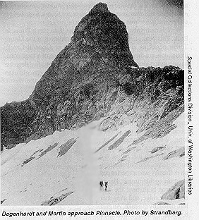
We left camp about 1:30 p. m., August 9, to climb Pinnacle Peak.
This peak stands out as the most prominent of the Mount Terror peaks as
viewed from the mouth of Goodell Creek, though it is not the highest. It
has the appearance of a huge cone, having its top lopped off at an angle of
about twenty-five degree.
An hour's climbing over granite slabs and snow brought us to the
base of a chimney in the east face of the peak. This chimney was easily
negotiated for some two hundred feet. The going from there on was not easy,
however, for the face became slabby and the pitches long. We were forced to
extend ourselves on a particularly bad pitch just below the summit slab.
The slab reached, no difficulty was experienced in attaining the summit.
Here a cairn was built near the east end of the ridge, and a register left,
dated, by mistake, August 8, 1932. Jim Martin remembers that the climbers
drank dehydrated coffee with the brand-name "G. Washington." As they
emptied the cans, they used them for summit registers. . . .
Turning our backs to Mount Despair, we look off to the East.
Immediately below us is a new field, probably three quarters of a mile
across, sloping gently upward to the rim of Crescent Creek Basin. . . It
terminates to the east in that vertical wall which forms the west wall of
Terror Creek, and extends almost its entire length.
This wall we have called the Barrier. It is from 500 to 1,500 feet
high, and almost unbroken for its entire length. We spent one day last year,
and almost two days this year trying to find the way down into Terror Creek,
or onto the glacier above. In those places attempted, the chimneys ended in
a vertical face, and in the places where it was possible to negotiate the
rock, it was impossible to get from the rock to the ice. In 1931, Bill
Degenhardt and I crossed the Barrier at a point near the head of the
glacier. Fortunately, it was freezing at the time, and we were not bothered
with falling rock. During the day, when the snow is melting, rock and snow
keep falling from pockets in the cliffs above, making this route extremely
hazardous, except when it is freezing. As it turned out, this falling rock
was the only thing that made this route possible because it bridged the gap
between the rock and ice.
Across the Barrier and Terror Creek beyond, we see the long ridge
which terminates at Newhalem, and beyond it one snow-capped peak after
another, many over 8,000 feet high. At the head of Terror Creek, are
several imposing rock peaks, which form the Terror-McMillan Creek divide.
These peaks seem to have only two dimensions--width and height. These would
offer most difficult climbing, in fact we might, without much danger of
contradiction, say that these peaks are impossible to climb. . .
Wonderful as the views to the west and east from Pinnacle
Peak are, they cannot be compared with that to the north. A mile and a half
to the northwest, is what we shall call West Peak aneroid elevation 7,300
feet. Strandberg's aneroid barometer was an early altimeter that measured
altitude by means of a vacuum and a mechanical indicator. It took a half
hour to get a reading, which they did not always have to spare. Strandberg,
the surveyor and mathematician, devised a formula for estimating their
altitude. It occupies much the same position with respect to the Crescent
Creek Basin as Pinnacle Peak. The basin is like a huge stadium open to the
west. Pinnacle and West Peak guard the western end. A long ridge in the
shape of a horseshoe connects these peaks. The ridge is nearly three miles
long, and consists of one sharp pinnacle after another rising from one
hundred to five hundred feet above the general level of the ridge and from
five hundred to two thousand feet above the snowfields and glaciers about
its base. They increase in height progressively to the east, the highest
being the true summit of Mount Terror aneroid elevation 8,360. The sheer
pinnacles standing side by side may have looked like a picket fence to early
pioneers, hence the name Picket Range.
The rock is, in general, granite, in some places weathered almost
black, in others gray, almost white, while in other places the rock is
stained deep red and brown. The floor of the basin is steep, and in winter
it is the scene of many avalanches, of which new scars near the tops of
trees give mute evidence. Between 5,100 and 6,500 feet, the basin is like a
huge rockery, alpine flowers of all kinds growing between rocks and
boulders. Within a hundred feet of camp were some twenty varieties of
alpine flowers in full bloom, a delightful contrast to the rugged peaks
about. Our camp (elevation 5,300) was located at timber line close to the
creek and above a big boulder. A month could be spent in this basin and one
could climb every day and never go up or down the same chimney or climb the
same peak twice, and every day would give a good climb. On this expedition,
we had time to climb only a few of the outstanding crags.
On August 16, we climbed West Peak. . .From the top we had a most
unusual view. The sky above was perfectly clear. Below, at elevation 6,000
feet, a sea of clouds extended in all directions, broken only by rugged
peaks, mere islands in this sea of fog. Jim Martin's enduring memory is of
the fog moving inland from Puget Sound, "spilling over the ridges like
water." We spent fully three hours on the summit, taking pictures and
locating peaks by compass. Bearings were taken on about forty of the more
prominent peaks, including Three Fingers and Whitehorse near Darrington. Far
to the southwest, the Olympics could be seen, a range of mountains on lthe
horizon. To the north, Mount Fury rises almost vertically from the depths of
Goodell Creek. A mile below us, through a break in the clouds, a silver
thread marked the course of Goodell Creek as it turns sharply to the
southeast on its way to the Skagit. To the northwest, we saw the lake which
lies in the pass at the head of Picket Creek, a tributary of the Baker
River. It does not seem possible that this pass can be approached from
Goodell Creek, as that side of the creek appears to be almost a solid
unbroken slab of granite of great height.
The view of the Mount Terror group, which is the rim of Crescent
Creek Basin, is ample reward for making this climb. A little more than a
half mile to the east are the two needles which stand so prominently
against the sky as one looks up Goodell Creek from the Skagit, or as viewed
from Pinnacle Peak.
On August 17, we climbed the one to the west. These afford some
most interesting climbs since it is impossible to plan a route to the
summit from below. The face is broken with chimneys running in every
direction, all extremely steep and full of chock stones. After entering any
of these chimneys from the glacier, little is left but to climb upward,
trusting that a continuous route to the summit can be found. We climbed a
long chimney which runs diagonally up the face. This chimney was found to
be continuous, except for an occasional steep grass slope ending in
vertical cliffs below. It is only 1,500 from the glacier to the summit,
(elevation 8,000), but it required almost six hours to make the ascent. . .
From the top, one could look almost vertically down on the McMillan Creek
glacier, a glacier of considerable size not shown on any maps. An excellent
view of the summit of Mount Terror is had, and to its right, the peak
climbed in 1931 by Bill Degenhardt and me . . .
The location of the summit of Mount Terror is somewhat indefinite
on the map. We assume that it is intended to be the highest of the peaks in
this group. Viewed from Pinnacle Peak, it appears as a pyramid, almost
vertical on the right, or east side, and sloping steeply upward from the
summit ridge on the west.
The route we followed, and probably the easiest one, can be seen
from this point. A snow-filled chimney leads up to a notch in the ridge
just west of the peak. This chimney is about six hundred feet long and is
very steep. After reaching the notch, we spent half a day trying to get up
the pitch immediately above, and it was only on the fourth attempt that we
succeeded after again resorting to tennis shoes. Our fourth attempt took us
through the notch to the snow on the far side, from which we had to jump to
a narrow ledge where the change of shoes was made. We then climbed nine
hundred feet in elevation along the summit ridge to the top. A cairn was
built about forty feet below the top, because the top was not large enough
to support such a structure. . .
The last day in Crescent Creek was spent in one last effort to
cross onto the glacier at the head of Terror Creek and reach those peaks on
the McMillan-Terror Creek divide. In this we were unsuccessful and we were
forced to abandon our revised plans of going out over Ross Mountain and had
to return by much the same route as used on our way in The rugged slopes
by this time had taken a toll on men and equipment. Martin remembers Bill
Degenhardt sitting on a rock in Goodell Creek, trying to restore his
climbing pants by pinning a bandana into what was left of the seat. Martin
spent more time in Degenhardt's company than Strandberg's. He remembers
Degenhardt as a wonderful storyteller who was always asked to describe his
climbs at the Wednesday evening Mountaineers club meetings. . . .
We saw no signs of anyone having been around these mountains before
us. . . Those who like to explore the unknown will find it of extreme interest.
An editorial observation: One marvels at the level of risk that Strandberg, Degenhardt, and Martin assumed. A single misstep, a disabling injury, and no help was in sight. No radio, no cell phone, no mountain rescue, and no helicopters; they were operating without a net. While their first ascents are comparatively easier with modern equipment and training methods, their daring was nothing less than heroic.
© 1998, The Mountaineers

Climb Up to Top Back
Back