By Herbert V. Strandberg Sr.
Bill Degenhardt, 1949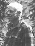 | To the mountaineer, the Skagit offers a multitude of interesting climbs of all kinds on snow, ice and rock. Its valleys are deep, peaks towering from 4,000 to 8,000 feet above the valleys below. It was with an idea of getting a birdís-eye view of this country, and enjoying some good climbing as well, that Wlliam A. Degenhardt and I left for the Skagit on Saturday, July 25, 1931, taking accessories ó rope, crampons, photographic equipment, etc. This was not Strandbergís first visit to the Skagit. As a college student he had trekked from the riverís mouth at Mt. Vernon all the way into Canada, surveying possible hydroelectric power sites. We arrived at Newhalem at 11 p.m. and before turning in, loaded our packs with three daysí supplies. |
Sunday morning, we took the excursion boat up to Ripraps, about four-and-a-half miles up the Skagit from Diablo.
In 1931, visitors rode the train or drove to Rockport. Then the Seattle City Light train took them to Newhalem. Although Strandberg is vague about this, they almost certainly took another train from Newhalem to Diablo. This leg of the trip ended after the incline lift brought rail cars 31 vertical feet up a 68-percent grade to the upstream side of Diablo Dam, which had just been finished. The excursion boat then continued up to Ripraps, a creek mouth just downstream from the current site of Ross Dam. Those touring the Seattle City Light project today take a similar tour. As a Seattle City Light engineer, Strandberg diverted Happy Creek to flow into the Ross Dam impoundment. this diversion was informally known as Strandberg Falls.
Prior to City Lightís railroad and the construction of the first Gorge Dam, in 1923, the only way up the Skagit from Newhalem was along the Goat Trail, a six-foot wide passage hewn into the rock that kept men and pack animals at the very brink of ferocious whitewater up to Diablo. The Skagit Gorge was only 13 feet wide in places along this stretch. The Devilís Elbow, now the location of the first single-lane tunnel on State Route 20, 1.5 miles above Newhalem, was the diciest spot, where the trail climbed a 40-foot cliff on a ladder. The trek to Ruby Creek, just above Ross Dam, took three days; modern-day travelers can drive the distance in a half-hour.
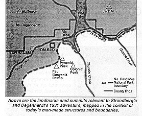
We then hiked up Ruby Creek about two-and-a-half miles, swung up the Jack Mountain trail and made camp near the temporary lookout on the summit of Little Jack (6,754 feet).
Herbert Strandberg, center, 1934 | We reached the summit at 2:30 p.m. and found it marked by a large cairn over five feet high...Jack Mountain was first climbed in 1904, according to Fred Beckey, "Cascade Alpine Guide." The view obtained from this mountain is rarely equaled. One can look for miles in all directions. Glacier Peak, Mount Baker and Mount Shuksan are familiar landmarks. There is a wonderful view of the mountains along Thunder and Goodell Creeks, the Picket range to the west, and the mountains in Canada to the north. We got back to high camp at 8 p.m. |
 Strandberg tells us how daunting the terrain could be.
...It took nine hours the next day to get down Ladder Creek to Newhalem, a distance of about four miles. We followed one-and-a-half miles of deer trail, which proved to be the easiest route down the cliffs into Ladder Creek. From then on it was a brush fight. The creek being too high to follow or cross, we had to take to the brush and timber. We finally came upon a trail, which runs for about three-quarters of a mile up the creek on the left bank...
From Newhalem, they took the train to Diablo to recover their baggage, then returned to Newhalem to approach Mt. Terror from Goodell Creek. Again, the undeveloped backcountry was rough going.
...We found, however, that the trail if the last two miles could be called that, ended in the creek bottom at 1,600 feet elevation. After a night on a gravel bar in Goodell Creek, and doing justice to an even dozen good-sized trout caught from a pool nearby, we started upward with our packs along a creek, which, our map indicated, flowed from the right ó or east ó side of Pinnacle Peak. This is a different mountain from the Pinnacle Peak on the Colonial Peak massif to the south. We had to travel by compass and good luck, for clouds were hanging on the mountaintops, hiding all landmarks.
We arrived at timberline at 7 p.m., after climbing 4,400 feet in two miles, through woods and brush. Adverse weather kept them from climbing the next day. Still, they continued their exploration of their fog-bound surroundings. ...(W)e spent an hour building a cairn and another hour exploring the ridges by throwing rocks and listening for their fall. By this method we could roughly determine the direction of the ridges, the width of the top and whether there were cliffs or heather slopes on the sides...
Stymied another day by the weather, they wound up their trip by heading for Diablo via Sourdough Mountain. On the way, they were able to add one last summit, the peak now known as Mt. Degenhardt. Strandbergís description of the journey home reminds us of the ruggedness of this land before roads and hiking trails penetrated the wilderness.
...This region is most rugged and inaccessible. Long broken ridges run in all directions, offering many varied and interesting rock climbs. On the McMillan Creek side there are several hanging glaciers, almost a thousand feet directly below, and I do not believe I was ever so impressed with the ruggedness of the mountains as when I looked down on their crevassed surfaces, especially since we had planned on crossing this ridge on what we supposed to be an easy route to Sourdough. At 5 p.m., we turned back down Crescent Creek, thence up to a notch just west of the peak we climbed. The other side of the ridge appeared to offer a route to the glacier south of Terror, so we started down.
We negotiated the first 100 feet before dark and spent three hours on the remaining 200 feet by flashlight. We carried heavy packs, the rock face was steep and treacherous, and the ledges and footholds filled with loose scree. We therefore roped in about thirty-five feet apart and proceeded cautiously. Only one of us moved at a time, while the other belayed the rope around rocks or by means of body belay. We found that with each of us alternately taking the lead, we could save considerable time in the handling of the rope. It then became necessary only to alter the position of the rope on the belay and pay it out, the man at the belay remaining in position with the rope coiled just as when he hauled it in. We finally made the glacier after crossing a bergschrund where it was bridged with fallen rock. A quarter moon rose, furnishing some light, and we worked our way down the glacier, around crevasses, and over snow bridges, which were by that time frozen solid. At 2:30 a.m., our way was blocked by another cliff, so we decided to catch a couple hours of sleep. After considerable searching we found a flat slab and a crack which would accommodate our sleeping bags.
Thus we ended a most interesting vacation, on which we made nine ascents. There was no evidence of previous ascent on any except Jack Mountain.
| About the Climbers: Herbert V. Strandberg (1901-83) received the Acheson Cup, precursor to The Mountaineers Service Award, in 1934. He served on glacial study teams on Mt. Baker throughout the 1930ís. He was chief engineer for Seattle City Light before his retirement. William A. Degenhardt (1902-56) served as president of The Mountaineers in 1952-54. He received The Mountaineers Service Award in 1952. The Mt. Baker Lodge was dedicated to his memory in 1959. |
July 1998
© 1998, The Mountaineers
 Climb Up to Top |
 Ten Days on Mount Terror Ten Days on Mount Terror |